File:Cloudburst damage of Hiroshima 5D5A0371.jpg

Original file (2,880 × 1,920 pixels, file size: 3.3 MB, MIME type: image/jpeg)
Captions
Captions
Summary[edit]
DescriptionCloudburst damage of Hiroshima 5D5A0371.jpg |
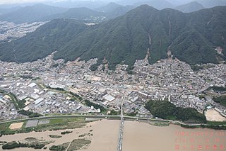
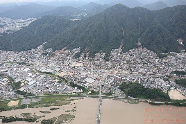
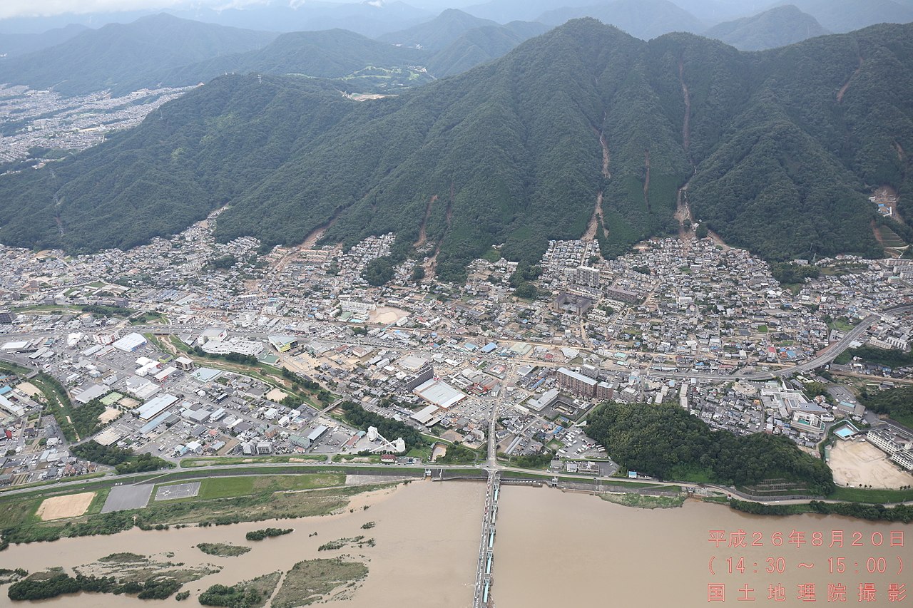
日本語: 平成26年8月豪雨による広島市の土砂災害 |
Date | |
Source | 平成26年(2014年)8月豪雨による被害状況に関する情報|国土地理院 |
Author | 国土地理院企画部防災推進室 |
Camera location | 34° 28′ 29.21″ N, 132° 30′ 23.87″ E ![]() ![]() | View this and other nearby images on: OpenStreetMap | ![]() |
---|
Licensing[edit]
![]() |
This work is licensed under the Government of Japan Standard Terms of Use (Ver.2.0). The Terms of Use are compatible with the Creative Commons Attribution License 4.0 International. For the terms of use of this work, see this license page.
English ∙ español ∙ 日本語 ∙ 한국어 ∙ македонски ∙ русский ∙ português ∙ slovenščina ∙ Tiếng Việt ∙ 简体中文 ∙ 繁體中文 ∙ +/− |


- You are free:
- to share – to copy, distribute and transmit the work
- to remix – to adapt the work
- Under the following conditions:
- attribution – You must give appropriate credit, provide a link to the license, and indicate if changes were made. You may do so in any reasonable manner, but not in any way that suggests the licensor endorses you or your use.
File history
Click on a date/time to view the file as it appeared at that time.
Date/Time | Thumbnail | Dimensions | User | Comment | |
---|---|---|---|---|---|
current | 03:38, 14 December 2017 | ![]() | 2,880 × 1,920 (3.3 MB) | M9106TB (talk | contribs) | User created page with UploadWizard |
You cannot overwrite this file.
File usage on Commons
There are no pages that use this file.
File usage on other wikis
The following other wikis use this file:
- Usage on ja.wikipedia.org
Metadata
This file contains additional information such as Exif metadata which may have been added by the digital camera, scanner, or software program used to create or digitize it. If the file has been modified from its original state, some details such as the timestamp may not fully reflect those of the original file. The timestamp is only as accurate as the clock in the camera, and it may be completely wrong.
Camera manufacturer | Canon |
---|---|
Camera model | Canon EOS 5D Mark III |
Copyright holder | GSI |
Exposure time | 1/1,000 sec (0.001) |
F-number | f/5 |
ISO speed rating | 1,000 |
Date and time of data generation | 14:56, 20 August 2014 |
Lens focal length | 26 mm |
Latitude | 34° 28′ 29.21″ N |
Longitude | 132° 30′ 23.87″ E |
Altitude | 738.9 meters above sea level |
Orientation | Normal |
Horizontal resolution | 72 dpi |
Vertical resolution | 72 dpi |
File change date and time | 14:56, 20 August 2014 |
Y and C positioning | Co-sited |
Exposure Program | Shutter priority |
Exif version | 2.3 |
Date and time of digitizing | 14:56, 20 August 2014 |
Meaning of each component |
|
APEX shutter speed | 10 |
APEX aperture | 4.625 |
APEX exposure bias | 0.33333333333333 |
Metering mode | Pattern |
Flash | Flash did not fire |
DateTime subseconds | 00 |
DateTimeOriginal subseconds | 00 |
DateTimeDigitized subseconds | 00 |
Supported Flashpix version | 1 |
Color space | sRGB |
Focal plane X resolution | 3,942.5051334702 |
Focal plane Y resolution | 3,950.6172839506 |
Focal plane resolution unit | inches |
Custom image processing | Normal process |
Exposure mode | Auto exposure |
White balance | Auto white balance |
Scene capture type | Standard |
GPS time (atomic clock) | 05:56 |
Satellites used for measurement | 11 |
Receiver status | Measurement in progress |
Measurement mode | 3-dimensional measurement |
Measurement precision | Fair (1.7) |
Speed of GPS receiver | 0 |
Direction of movement | 0 |
Reference for direction of image | Magnetic direction |
Direction of image | 298 |
Geodetic survey data used | WGS-84 |
Bearing of destination | 0 |
Distance to destination | 0 |
GPS date | 20 August 2014 |
GPS differential correction | 0 |
GPS tag version | 0.0.3.2 |
Rating (out of 5) | 0 |